a small test in the park

with the roll cage transplant done, testing the temporary steering servo mount mod
Rugged, Full-featured Handheld with GPS, GLONASS and Wireless Connectivity. 2.6-inch sunlight-readable color screen. High-sensitivity GPS and GLONASS receiver with quad helix antenna. Preloaded TOPO EU Recreation 100K maps plus a 1-year BirdsEye Satellite Imagery subscription. 3-axis compass with barometric altimeter. Wireless connectivity via Bluetooth® technology¹ or ANT+®.
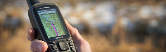
GPSMAP 64st
GPSMAP 64st features a 2.6-inch sunlight-readable color screen and a high-sensitivity GPS and GLONASS receiver with a quad helix antenna for superior reception. GPSMAP 64st includes a 3-axis electronic compass with barometric altimeter, wireless connectivity and preloaded TOPO EU Recreation 100K maps plus a 1-year BirdsEye Satellite Imagery subscription.
Explore the Terrain
The GPSMAP 64st comes with pre-loaded recreational maps from 44 European countries. The map data includes information about the road network (not navigable), forests, terrain contours, altitude, lakes and points of interest. The handheld has an extensive set of navigation functions, so you can rely on via points, tracks and routes to find your way off the beaten track and with TracBack you can safely find your way back.

Get Your Bearings
GPSMAP 64st has a built-in 3-axis tilt-compensated electronic compass, which shows your heading even when you’re standing still, without holding it level. Its barometric altimeter tracks changes in pressure to pinpoint your precise altitude, and you can even use it to plot barometric pressure over time, which can help you keep an eye on changing weather conditions.
Read more